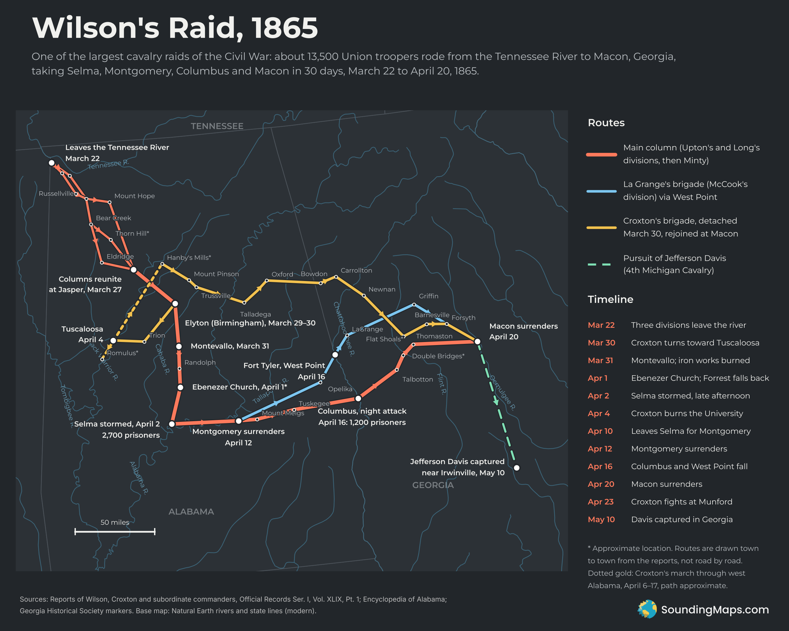
At 8:30 p.m. on April 16, 1865, about 300 dismounted troopers of the 3rd Iowa Cavalry attacked Columbus, Georgia. By the end of the night, the Union had the city, its bridges, 1,200 prisoners and 52 field guns. Lee had surrendered in Virginia a week earlier. News of it had not yet reached Wilson’s men.
Columbus was one stop on Wilson’s Raid. In 30 days, about 13,500 Union cavalrymen under Brevet Major General James H. Wilson rode from the Tennessee River to Macon. Along the way they took Selma, Montgomery, Columbus and Macon and wrecked much of the Deep South’s remaining war industry.
Three columns through the hills
Wilson spent the winter of 1864–65 drilling his corps in northwest Alabama. Most of his troopers carried seven-shot Spencer repeating rifles. On March 22, 1865, they left the Tennessee River in three divisions under Emory Upton, Eli Long and Edward McCook.
Rain had swollen every stream, so the divisions took separate roads to move faster. Upton went by Barton’s Station, Russellville and Mount Hope. Long and McCook went through Cherokee, Russellville and Bear Creek. All three came together near Jasper and crossed both forks of the Black Warrior River. Wilson left his wagons in the forks of the river and pushed on.
Upton reached Elyton, the village that later became part of Birmingham, on March 29. The other divisions arrived the next day. Raiders burned the iron furnaces nearby.
Croxton’s detour
On March 30, Wilson detached John T. Croxton’s brigade, about 1,500 men, toward Tuscaloosa. Croxton crossed the Black Warrior and took the town on the night of April 3. On April 4 his men burned the University of Alabama, which trained cadets for the Confederacy.
Croxton then lost touch with the main column. On April 6 he fought William Wirt Adams’s cavalry near Romulus, southwest of Tuscaloosa. For the next 11 days his brigade worked north through the hills of west Alabama. It crossed the Sipsey Fork on April 15 and the Mulberry Fork at Hanby’s Mills on April 17.
From there Croxton turned east. He passed Mount Pinson and Trussville, crossed the Coosa on April 21, and fought at Munford on April 23. His men reached Carrollton, Georgia, on April 26 and Newnan the next day. They crossed the Flint at Flat Shoals and passed Barnesville and Forsyth. Croxton rejoined Wilson at Macon on May 1.
Montevallo, Ebenezer Church and Selma
The main column crossed the Cahaba on the railroad bridges at Hillsborough on March 31. That day Upton drove Nathan Bedford Forrest’s cavalry out of Montevallo and burned the iron works there.
On April 1, Forrest tried to stop Wilson near Ebenezer Church, about 20 miles north of Selma. The 17th Indiana charged first. Upton then hit the Confederate flank and took two guns and about 300 prisoners. Forrest fell back to Selma.
Selma was the prize, with an arsenal, a naval foundry and major ironworks. On the afternoon of April 2, Long attacked the city’s works with 1,160 dismounted men. They broke through at a cost of 46 killed and 200 wounded. Upton’s men followed as night fell. Wilson reported 2,700 prisoners, 26 field guns and about 70 heavy guns. Forrest escaped with about half his force.
Wilson stayed in Selma until April 10. His troops destroyed the arsenal, shops and foundries. On April 6 he met Forrest under a flag of truce at Cahaba. Engineers laid a pontoon bridge across the Alabama River, and high water broke it three times.
Montgomery to Macon
On April 12, McCook’s men reached Montgomery at 7 a.m., and the city surrendered. Confederate troops had already burned about 85,000 bales of cotton and pulled out.
From Montgomery, the corps split again on April 14. Upton marched through Mount Meigs and Tuskegee toward Columbus. Robert Minty, now leading Long’s division, took the direct road. Oscar La Grange’s brigade followed the railroad through Opelika to West Point, Georgia.
Both fights came on April 16, Easter Sunday. Earlier that day La Grange stormed Fort Tyler, a small earthwork above West Point, and took nearly 300 prisoners. After dark, Upton’s men took Columbus. The next day Colonel Edward Winslow’s troopers burned the navy yard and the ironclad ram CSS Jackson.
Minty’s division took the Thomaston road toward Macon. A night march seized the Double Bridges over the Flint River by 7 a.m. on April 18. Meanwhile La Grange rode east through LaGrange, Griffin and Forsyth, cutting railroads. On the evening of April 20, the 17th Indiana reached Macon. Major General Howell Cobb surrendered the city without a fight. The raid was over.
The capture of Jefferson Davis
On May 10, the 4th Michigan Cavalry, part of Wilson’s corps, captured Jefferson Davis near Irwinville, Georgia. The dashed line on the map shows that final leg.
How the map was made
The routes follow the towns named in the official reports of Wilson, Croxton and their brigade commanders. Lines connect those towns in order, so they show the general path, not exact roads. We checked town positions against the GeoNames gazetteer. An asterisk marks places whose 1865 locations are uncertain, such as Thorn Hill, Hanby’s Mills and the Double Bridges. Croxton’s report names creeks and ferries in west Alabama that are hard to pin down. A dotted line marks that stretch. The rivers and state lines come from modern Natural Earth data.
The map comes in three styles: light atlas, dark charcoal and warm stone.
Sources
- Reports of James H. Wilson, John T. Croxton and brigade commanders, in The War of the Rebellion: Official Records of the Union and Confederate Armies, Series I, Vol. 49, Part 1, pp. 350–365 and 423–429 (text via civilwar.com).
- Encyclopedia of Alabama, “Wilson’s Raid” and “Croxton’s Raid.”
- Georgia Historical Society, “Double Bridges” and “Wilson’s Raid to Macon” historical markers.
- GeoNames gazetteer (town positions); Natural Earth (rivers and state boundaries).