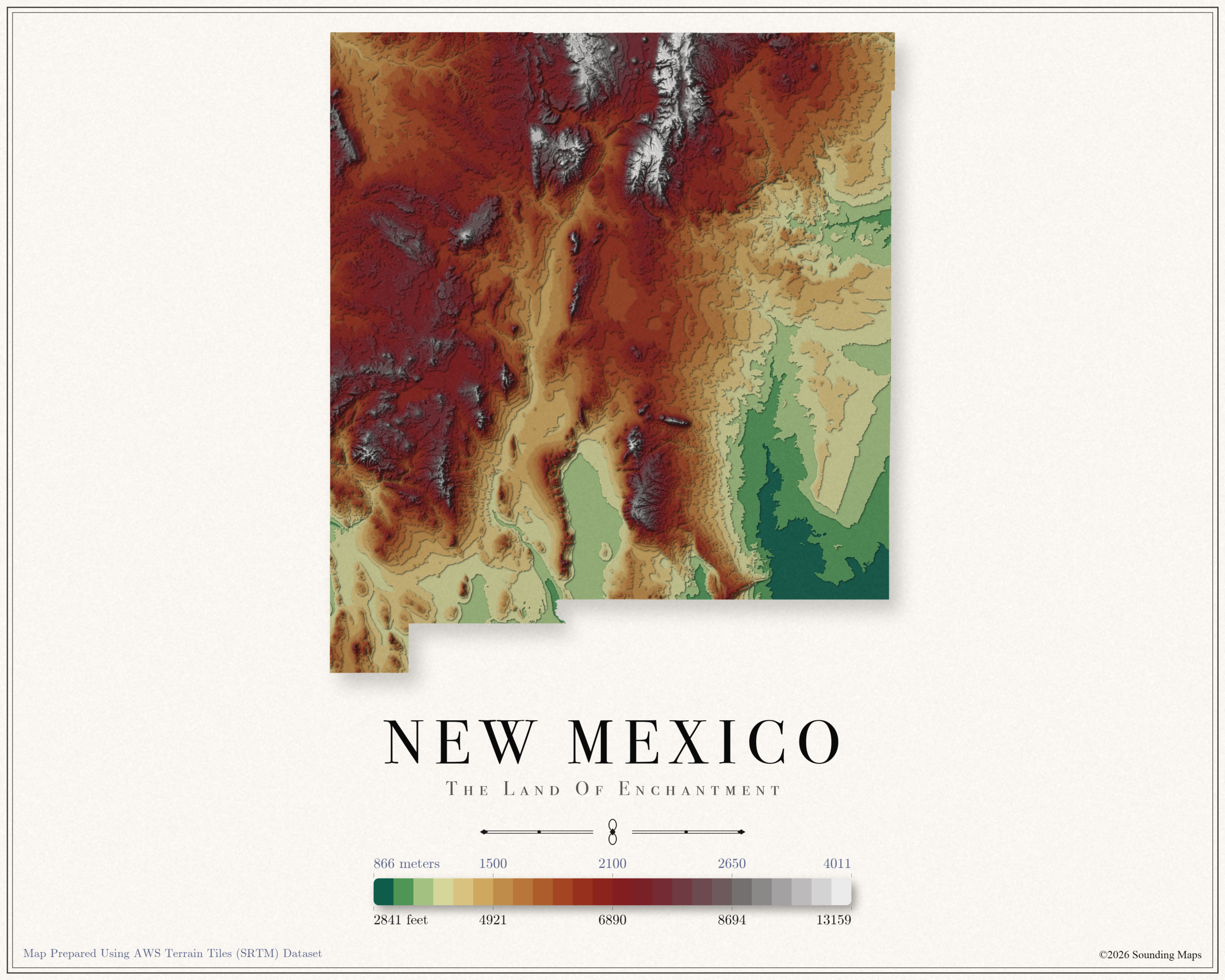
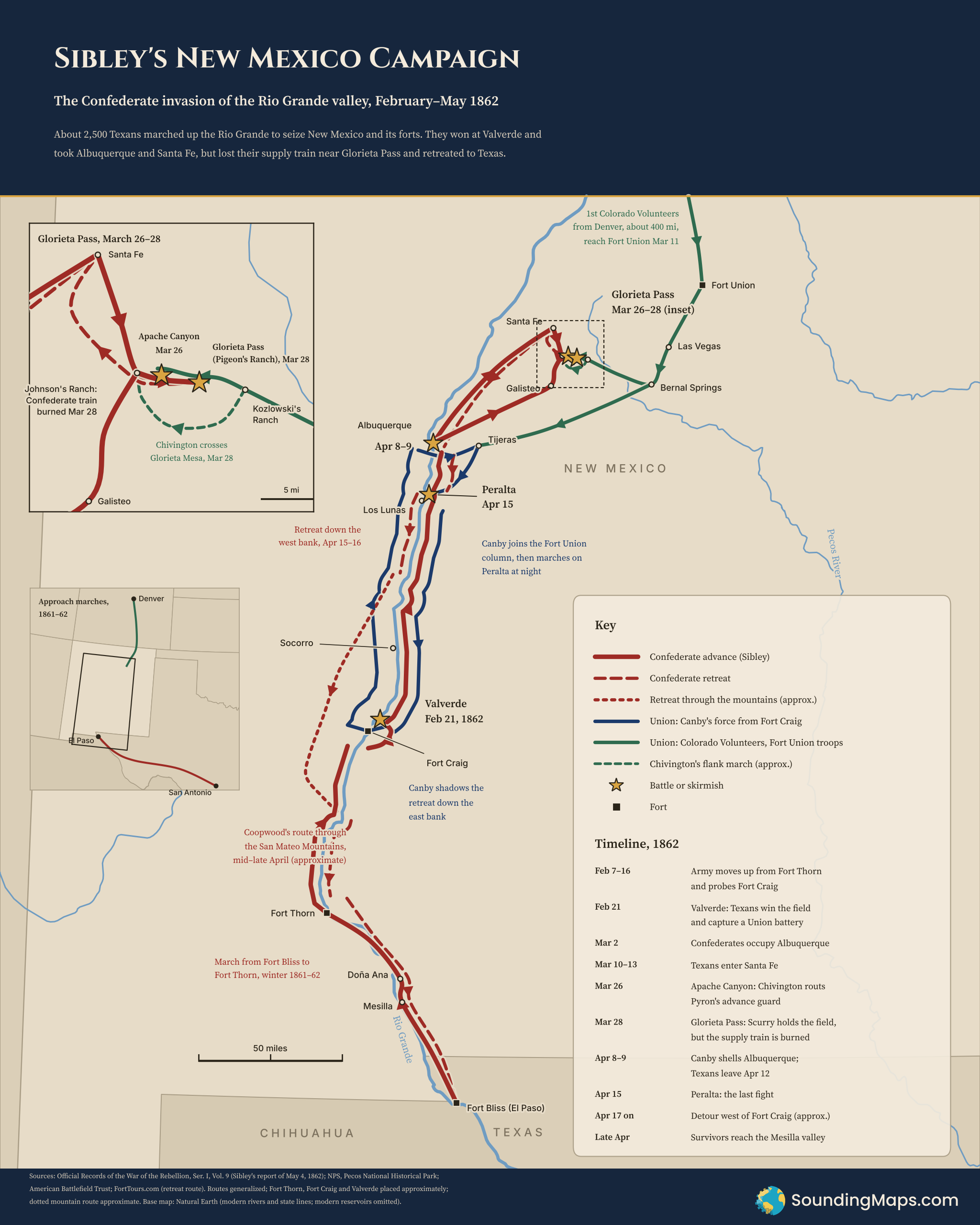
In February 1862, about 2,500 Texans marched up the Rio Grande to take New Mexico for the Confederacy. Brig. Gen. Henry Hopkins Sibley led them. Three months later his army was back near El Paso, short nearly 40 percent of its men. The map traces that loop. It runs north along the river, east to Santa Fe and Glorieta Pass, and home through the mountains.
The plan and the march north
Sibley’s goal reached beyond New Mexico. He hoped to seize the territory’s forts and supplies, then look toward Colorado’s gold fields and California. Sibley raised three mounted regiments in Texas in 1861. His men gathered at Fort Bliss, then moved up to Mesilla, Doña Ana and old Fort Thorn.
Sibley’s own report gives the timeline. His army started north from Fort Thorn on February 7 and camped 7 miles below Fort Craig. On February 16 he probed the fort and found it too strong to storm. Col. Edward Canby held it with regulars and New Mexico volunteers.
Sibley chose to go around. His army crossed to the east bank of the Rio Grande. It made a dry camp in the sand hills opposite the fort. The move threatened Canby’s supply line to the north.
Valverde, February 21
Both armies raced for the ford at Valverde, about six miles above Fort Craig. Sibley fell ill during the day and handed command to Col. Tom Green. Late in the afternoon the Texans charged and overran a Union battery. Canby’s men fell back across the river to the fort.
The American Battlefield Trust puts losses at about 276 Union and 229 Confederate. Sibley’s men held the field and took six guns. They still could not take Fort Craig, which sat behind them for the rest of the campaign.
Albuquerque, Santa Fe and Glorieta Pass
Sibley kept moving north. He left his sick at Socorro, and his army reached Albuquerque on March 2. An advance squad rode into Santa Fe on March 10, and the main force arrived by March 13. Retreating Union troops burned supplies as they left. Sibley’s men still found stores at Albuquerque and at Cubero, a post 60 miles to the west.
The next target was Fort Union, the big Union depot northeast of Santa Fe. By then the fort had help. The 1st Colorado Volunteers had marched roughly 400 miles from Denver and reached it on March 11.
Union and Confederate troops met in the narrow canyons of the Santa Fe Trail. On March 26 Maj. John Chivington’s advance hit Maj. Charles Pyron’s Texans in Apache Canyon and drove them back. On March 28 Lt. Col. William Scurry attacked the main Union force at Pigeon’s Ranch. Scurry pushed the Federals back through the pass and thought he had won.
Behind him, the battle turned. About 500 Union troops had crossed Glorieta Mesa and come down on the Confederate camp at Johnson’s Ranch. They burned the supply train, about 80 wagons, and killed or drove off the animals. Without food, ammunition or blankets, Scurry had to fall back to Santa Fe.
The retreat
Sibley’s army could no longer stay in New Mexico. It pulled back to Albuquerque in early April. Canby came north from Fort Craig and shelled the town on April 8 and 9. On April 13 he joined the column from Fort Union at Tijeras, east of Albuquerque.
Sibley left Albuquerque on April 12. Green’s regiment camped at Peralta, on the east bank opposite Los Lunas. Canby attacked it there on April 15, and a sandstorm ended the fight. Some accounts date the action to April 14. That night the Texans crossed to the west bank.
Fort Craig still blocked the road south. Rather than fight past it, Sibley sent his army into the mountains west of the river. Maj. Bethel Coopwood guided the column. Sibley described “a route through the mountains, avoiding Fort Craig and striking the river below that point.” The men abandoned most wagons and packed seven days of food on mules. They hauled the Valverde guns up canyons with ropes. After about a week in the mountains, they struck the river below the fort. They then crossed to the east bank.
The survivors reached the Mesilla valley in late April. Sibley wrote his campaign report from Fort Bliss on May 4. Over the campaign his army lost roughly 1,000 men, close to half of them missing or captured.
Why it mattered
Glorieta Pass ended the Confederate push into the Far West. The fight itself was close. Losing the supply train decided it, because Sibley’s army lived on what it carried and captured. Historians sometimes call the battle the “Gettysburg of the West.” The phrase oversells its size, but the Union did keep the Southwest for the rest of the war.
Methodology and sources
We built the route mainly from Sibley’s report of May 4, 1862. It appears in the Official Records of the War of the Rebellion, Series I, Volume 9, pages 506–512 (civilwar.com transcription). Glorieta details come from the National Park Service, Pecos National Historical Park.
We also used the NPS battle summary and the American Battlefield Trust. Valverde figures come from the American Battlefield Trust. Details of the mountain retreat come from Sibley’s report and Fort Tours. Overall strength and losses follow the summary in Wikipedia’s Army of New Mexico article, which cites the standard histories.
Routes are generalized. Marches along the Rio Grande follow the river and show which bank each force used. The mountain route and Chivington’s flank march are approximate, since no source gives an exact track. Fort Thorn, Valverde and Fort Craig are placed approximately on a simplified river line. The base map uses Natural Earth’s modern rivers and state lines. In 1862, New Mexico Territory also included today’s Arizona. Elephant Butte and Caballo reservoirs did not exist yet, so the map leaves them out.